WRPM: A Digital Observatory Water and Agriculture, and a DSS Platform for Water Management and Planning in the WEFE Nexus
Ali HAMMANI
March 21, 2026 • Updated March 21, 2026
How do we plan water futures when climate uncertainty is rising, agricultural demand is growing, and decisions in one sector immediately affect others? This is the challenge that WRPM was built to address.
WRPM, short for Water Resource Management and Planning through Water-Accounting in the framework of the WEFE Nexus, is more than a software project. It is a digital environment designed to connect data, analysis, and decision-making across water, energy, food, and ecosystems.
At the heart of this platform is the Digital Observatory of Water and Agriculture.
This observatory is the knowledge engine of WRPG. It brings together geospatial information, climate records, hydrological monitoring, agricultural data, and water-accounting logic into a single analytical space. Before stakeholders can build scenarios or negotiate future choices, they need a shared understanding of the current system. the observatory provides that foundation.
Why an observatory matters
Water planning often suffers from fragmentation.
Hydrological data may sit in one system. Agricultural statistics in another. Climate records in a separate archive. Maps, spreadsheets, and reports rarely speak the same language.
The result is familiar: decisions are made with partial visibility.
The WRPM Observatory was designed to reduce that fragmentation. It creates a common spatial and analytical reference for understanding how water and agriculture interact across territories, infrastructures, and time.
Instead of asking only “how much water do we have?”, the platform helps answer broader and more useful questions:
- Where is water available?
- Who uses it?
- Which territories are most exposed?
- How is agriculture structured on the ground?
- How do climate signals evolve over time?
- And what do these dynamics mean for future planning?
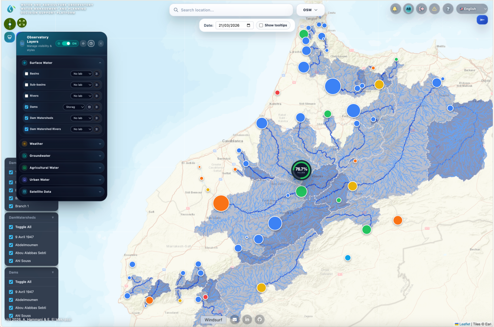
A map-based view of water and agriculture
The observatory part is built as a geospatial observatory using using modern Web Applcations Development tools and gounded on robust database management system.
It organizes information across multiple territorial levels, including country, region, province, commune, basin, sub-basin, watershed, aquifer, irrigation perimeter, and. This makes it possible to move from national-scale patterns to local realities.
On top of these territorial layers, the observatory maps the main physical and institutional components of water management:
Dams, rivers, canals, irrigation networks, aquifers, wells, hydrological stations, weather stations, piezometers, wastewater stations, desalination plants, cities, and agricultural systems.
This is important because water planning is never just about natural resources. It is also about infrastructure, service systems, and the way people actually use water in agriculture and beyond.
Connecting agriculture to water realities
One of the strongest dimensions of the observatory is its agricultural intelligence.
The platform includes crop information, irrigation modes, water sources, energy types, and soil occupation data. It captures not only where farming takes place, but also how production systems are organized and how they interact with water resources.
This allows the observatory to connect agricultural land use with hydrological and climatic conditions.
In practical terms, that means the platform can support a more integrated understanding of irrigated agriculture, rainfed systems, crop patterns, and water demand. It helps move from abstract planning to spatially grounded analysis.
From static data to a living data pipeline
The WRPM Observatory is not a static map portal.
It is built around data ingestion and update workflows that keep the knowledge base alive.
Within the Digital Observatory, dedicated pipelines collect and process data from multiple sources, including climate services, Earth observation products, and monitoring records. The platform includes workflows for daily weather grids, monthly TerraClimate data, WaPOR-derived indicators, dam-level updates, and aggregated climate summaries optimized for analysis.
This matters because observatories only become useful when they are able to evolve with the system they monitor.
A living observatory supports not just description, but continuous learning.
From observation to analysis
What makes the observatory particularly valuable is that it does not stop at storing data.
It also turns data into services.
The observatory exposes analytical tools for climate evolution, evapotranspiration, water balance, soil occupation, weather interpolation, solar radiation assessment, and more. Users can explore these results through interactive spatial layers, charts, and map-based tools.
This analytical layer is essential in the WEFE context. Decision-makers do not only need data tables. They need interpretable signals.
Understanding systems, not just points
The observatory also shows a strong systems perspective.
One of the most interesting examples is the dam and watershed workflow. The platform can delineate dam watersheds from digital elevation models, compute watershed metrics, and relate those watershed characteristics to rainfall and reservoir dynamics.
This kind of functionality pushes the observatory beyond inventory and toward explanation.
It begins to answer not only what exists, but why certain water dynamics emerge in specific places.
That is a key shift for planning under uncertainty.
Water accounting as a bridge to decision-making
This is not only a database of water-related objects. It is an application built around water accounting.
The platform includes structures for representing inflows, outflows, storage, recharge, demand, return flows, and environmental fluxes. It helps translate a complex territorial system into understandable water-balance logic.
That is especially valuable when different sectors compete for the same resource.
Water accounting creates a shared language between hydrologists, agricultural planners, public agencies, and other stakeholders. It makes trade-offs more visible and helps discussions move from assumptions to evidence.
The observatory as the foundation of participatory planning
WRPM contains two major applications : if the first is the Digital Observatory,of Water and Agriculture, the second is tha analysis and the develoment of water management and planning scenarios with participation of all the stakeholders.
These two parts are deeply complementary.
The observatory provides the evidence base. The scenario layer provides the participatory space.
This architecture is one of the most promising aspects of the WRMP project. It means the platform is not limited to monitoring. It is designed to support co-construction, dialogue, and exploration of future options.
In other words, the observatory does not replace participation. It strengthens it.
Discussion
Join the conversation
Join the discussion
Sign in to share your thoughts
No comments yet
Be the first to share your thoughts on this article!